Geolocate

Sikat topographic map

Click on the map to display elevation.

About this map

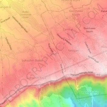
Name: Sikat topographic map, elevation, terrain.

Location: Sikat, Alfonso, Cavite, Calabarzon, 4123, Philippines (14.07605 120.86873 14.11605 120.90873)

Average elevation: 545 m

Minimum elevation: 256 m

Maximum elevation: 664 m

Other topographic maps

Click on a map to view its topography, its elevation and its terrain.

Amuyong

Philippines > Cavite > Alfonso

Average elevation: 543 m

Amuyong

Philippines > Cavite > Alfonso

Average elevation: 543 m

Gear up for your next adventure:

🧰Survival Kit - Essential gear for emergencies in the wilderness
🔪Outdoor Multitool - Versatile tool for repairs and food prep in the wild
❄️Traction Ice Cleats - Slip-on spikes for icy trails and winter hiking
👟Leg Gaiters - Keep debris, mud, and snow out of your boots
🏕️Camping Hammock - Integrated protection for sleeping between trees

As an Amazon Associate, this site earns from qualifying purchases at no extra cost to you.