Geolocate

Lecce topographic map

Click on the map to display elevation.

About this map

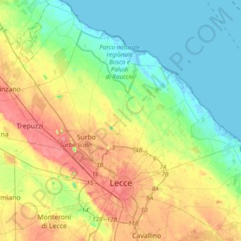
Name: Lecce topographic map, elevation, terrain.

Location: Lecce, Apulia, 73100, Italy (40.31239 18.03991 40.50640 18.30737)

Average elevation: 24 m

Minimum elevation: -4 m

Maximum elevation: 61 m

Other topographic maps

Click on a map to view its topography, its elevation and its terrain.

Santa Maria di Leuca

Italy > Apulia > Lecce

Average elevation: 33 m

Santa Maria al Bagno

Italy > Apulia > Lecce > Nardò

Average elevation: 32 m

Torre Chianca

Italy > Apulia > Lecce > Lecce

Average elevation: 2 m

Gear up for your next adventure:

🔭Compact Binoculars - Lightweight optics for scouting trails and wildlife
💧Reusable Water Bottle - Durable water bottles for hydration on trails
🧢Outdoor Cap - Protective cap for sun and rain during hikes
📷Outdoor Action Camera - Capture high-elevation views and rugged adventures
🧥Thermal Fleece Jacket - Versatile insulation for changing mountain temperatures

As an Amazon Associate, this site earns from qualifying purchases at no extra cost to you.