
Thank you for supporting this site ❤️
Make a donation
Make a donation
Gear up for your next adventure:
As an Amazon Associate, this site earns from qualifying purchases at no extra cost to you.
Seelow topographic map
Click on the map to display elevation.
Thank you for supporting this site ❤️
Make a donation
Make a donation
Gear up for your next adventure:
As an Amazon Associate, this site earns from qualifying purchases at no extra cost to you.
About this map
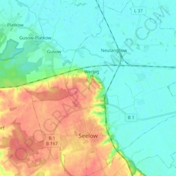
Name: Seelow topographic map, elevation, terrain.
Location: Seelow, Märkisch-Oderland, Brandenburg, 15306, Germany (52.51253 14.33758 52.59509 14.47036)
Average elevation: 25 m
Minimum elevation: 5 m
Maximum elevation: 68 m
Thank you for supporting this site ❤️
Make a donation
Make a donation
Gear up for your next adventure:
As an Amazon Associate, this site earns from qualifying purchases at no extra cost to you.
Other topographic maps
Click on a map to view its topography, its elevation and its terrain.
Birkenstein
Germany > Brandenburg > Märkisch-Oderland > Hoppegarten > Dahlwitz-Hoppegarten
Average elevation: 55 m