Geolocate

Oroville topographic map

Click on the map to display elevation.

👉 Easily get elevation data in JSON, GeoTIFF and KML formats using Elevation API
Thank you for supporting this site ❤️
Make a donation

About this map

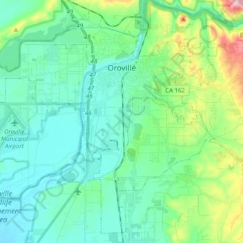
Name: Oroville topographic map, elevation, terrain.

Location: Oroville, Butte County, California, 95965, United States (39.44148 -121.63982 39.53868 -121.50262)

Average elevation: 85 m

Minimum elevation: 31 m

Maximum elevation: 281 m

Other topographic maps

Click on a map to view its topography, its elevation and its terrain.

Jonesville

United States > California > Butte County

Average elevation: 1,663 m

Gear up for your next adventure:

🛶Kayak Dry Bag - Waterproof storage for kayaking adventures
🧥Fleece Jacket - Warm and lightweight jacket for layering
🥾Mountaineering Boots - Supportive boots for climbing and high-altitude hiking
🔋Lithium AA Batteries - Long-lasting power that performs in extreme cold
🧭GPS Tracker - Track your location in remote areas safely

As an Amazon Associate, this site earns from qualifying purchases at no extra cost to you.