
Littleton topographic map
Click on the map to display elevation.
About this map
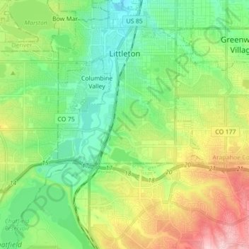
Name: Littleton topographic map, elevation, terrain.
Location: Littleton, Arapahoe County, Colorado, 80120, United States (39.53536 -105.11199 39.62996 -104.97325)
Average elevation: 1,684 m
Minimum elevation: 1,610 m
Maximum elevation: 1,831 m
Other topographic maps
Click on a map to view its topography, its elevation and its terrain.
Littleton
United States > Colorado > Arapahoe County > Littleton > Littleton
Littleton is located at 39°35′59″N 105°0′39″W / 39.59972°N 105.01083°W / 39.59972; -105.01083 (39.599691, −105.010929) at an elevation of 5,351 feet (1,631 m). Located in central Colorado at the junction of U.S. Route 85 and Colorado State Highway 470, the city is 9 miles (14 km) south…
Average elevation: 1,656 m