Geolocate

Iracema topographic map

Click on the map to display elevation.

About this map
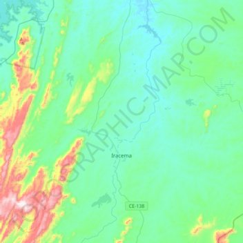
Name: Iracema topographic map, elevation, terrain.

Location: Iracema, Região Geográfica Imediata de Russas - Limoeiro do Norte, Região Geográfica Intermediária de Quixadá, Ceará, Northeast Region, 62980-000, Brazil (-5.92458 -38.49087 -5.60144 -38.14580)

Average elevation: 195 m

Minimum elevation: 69 m

Maximum elevation: 740 m

Other topographic maps

Click on a map to view its topography, its elevation and its terrain.
Buenos Aries

Brazil > Ceará > Alcântaras

Average elevation: 743 m

Machuca

Brazil > Ceará > Aquiraz

Average elevation: 19 m

Gear up for your next adventure:

🧼Travel Hand Sanitizer - Keep hands clean when water is scarce
🧦Crew Hiking Socks - Comfortable socks for long-distance hikes
🪜Heavy Duty Carabiners - Multi-use clips for securing gear to your backpack
🧢Sun Hat - Wide-brim hat for sun protection
🧥Softshell Hiking Jacket - The perfect balance of wind protection and breathability

As an Amazon Associate, this site earns from qualifying purchases at no extra cost to you.