Geolocate

Danbury topographic map

Click on the map to display elevation.

Danbury

Danbury is located at 46.006N. The longitude is -92.371W. It is in the Central Standard Time Zone. The elevation is 938 feet (286 m) above sea level.

Wikipedia (CC-BY-SA 3.0)

About this map

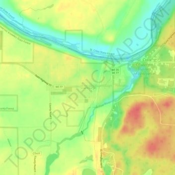
Name: Danbury topographic map, elevation, terrain.

Location: Danbury, Town of Swiss, Burnett County, Wisconsin, United States (45.98661 -92.39130 46.02661 -92.35130)

Average elevation: 287 m

Minimum elevation: 259 m

Maximum elevation: 312 m

Gear up for your next adventure:

🥫Freeze-Dried Meals - Lightweight, high-calorie nutrition for multi-day treks
🧤Rechargeable Heated Gloves - Extreme warmth for Canadian winter expeditions
💧Collapsible Water Bottle - Space-saving water bottle for outdoor activities
🔦LED Headlamp - Hands-free lighting for early morning starts or late finishes
🎒Backpack Rain Cover - External shield to keep your entire pack dry

As an Amazon Associate, this site earns from qualifying purchases at no extra cost to you.