Geolocate

Cartagena topographic map

Click on the map to display elevation.

About this map

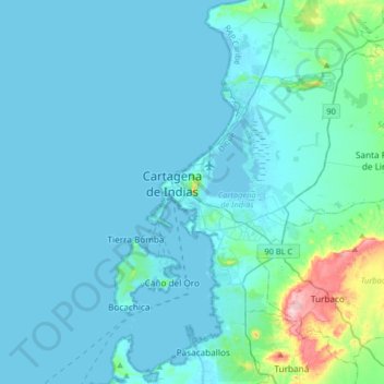
Name: Cartagena topographic map, elevation, terrain.

Location: Cartagena, Cartagena de Indias, Bolívar, 3110, Colombia (10.25958 -75.68712 10.57958 -75.36712)

Average elevation: 21 m

Minimum elevation: -2 m

Maximum elevation: 238 m

Other topographic maps

Click on a map to view its topography, its elevation and its terrain.

Ciénaga de la Virgen

Colombia > Bolívar > Cartagena

Average elevation: 3 m

Gear up for your next adventure:

🦶Hiking Shoe Insoles - Added support for high arches and long days on feet
🗺️Topographic Maps - Detailed maps to explore trails, mountains, and wilderness areas
🔥Emergency Fire Starter - Reliable ignition source for all weather conditions
🧤Rechargeable Heated Gloves - Extreme warmth for Canadian winter expeditions
🚑Survival Whistle - Signal for help across long distances in mountains

As an Amazon Associate, this site earns from qualifying purchases at no extra cost to you.