
Thank you for supporting this site ❤️
Make a donation
Make a donation
Gear up for your next adventure:
As an Amazon Associate, this site earns from qualifying purchases at no extra cost to you.
Wānaka topographic map
Click on the map to display elevation.
Thank you for supporting this site ❤️
Make a donation
Make a donation
Gear up for your next adventure:
As an Amazon Associate, this site earns from qualifying purchases at no extra cost to you.
About this map
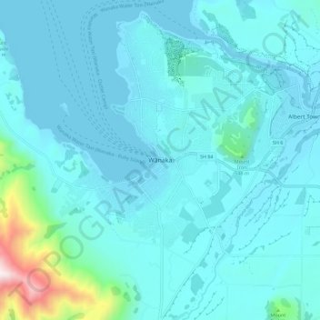
Name: Wānaka topographic map, elevation, terrain.
Average elevation: 381 m
Minimum elevation: 278 m
Maximum elevation: 1,287 m
Thank you for supporting this site ❤️
Make a donation
Make a donation
Gear up for your next adventure:
As an Amazon Associate, this site earns from qualifying purchases at no extra cost to you.
Other topographic maps
Click on a map to view its topography, its elevation and its terrain.
Lake Hāwea
New Zealand > Otago > Queenstown-Lakes District
Lake Hāwea is New Zealand's ninth largest lake located on the South Island in the Otago Region at an altitude of 348 m. It covers 141 km2 and is 392 m deep.
Average elevation: 864 m