
Salerno topographic map
Interactive map
Click on the map to display elevation.
About this map
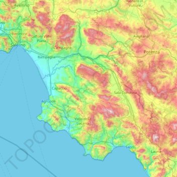
Name: Salerno topographic map, elevation, terrain.
Location: Salerno, Campania, Italy (39.99052 14.42830 40.84875 15.80645)
Average elevation: 464 m
Minimum elevation: -2 m
Maximum elevation: 1,987 m
Other topographic maps
Click on a map to view its topography, its elevation and its terrain.
Serralunga
Italy > Campania > Salerno > Tortorella
Serralunga, Tortorella, Salerno, Campania, Italy
Average elevation: 1,156 m
San Pietro Infine
San Pietro Infine, Caserta, Campania, Italy
Average elevation: 320 m
Monteverde
Italy > Campania > Monteverde
Monteverde, Avellino, Campania, Italy
Average elevation: 469 m
Rocca d'Evandro
Italy > Campania > Caserta > Rocca d'Evandro
Rocca d'Evandro, Caserta, Campania, Italy
Average elevation: 228 m