Geolocate

Medininagar topographic map

Click on the map to display elevation.

Medininagar

Medininagar is located at 24°02′N 84°04′E / 24.03°N 84.07°E / 24.03; 84.07. It has an average elevation of 215 m (705 ft).

Wikipedia (CC-BY-SA 3.0)

About this map

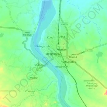
Name: Medininagar topographic map, elevation, terrain.

Location: Medininagar, Medininagar(Daltonganj), Palamu District, Jharkhand, 822101, India (23.99972 84.02581 24.07972 84.10581)

Average elevation: 226 m

Minimum elevation: 196 m

Maximum elevation: 308 m

Gear up for your next adventure:

💧Hydration Bladder - Hands-free hydration solution for long treks
🥾Approach Shoes - Shoes designed for climbing approaches and rugged trails
🥾Trekking Poles - Adjustable trekking poles to reduce knee stress and improve stability
🪑Ultralight Camping Stool - Compact seating for rest stops during long hikes
🛁Quick-Dry Microfiber Towel - Space-saving towel that dries rapidly on the move

As an Amazon Associate, this site earns from qualifying purchases at no extra cost to you.