Geolocate

Lake Alfred topographic map

Click on the map to display elevation.

About this map

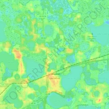
Name: Lake Alfred topographic map, elevation, terrain.

Location: Lake Alfred, Polk County, Florida, 33850, United States (28.06615 -81.75703 28.15744 -81.67363)

Average elevation: 41 m

Minimum elevation: 30 m

Maximum elevation: 60 m

Other topographic maps

Click on a map to view its topography, its elevation and its terrain.

Iron Mountain

United States > Florida > Polk County

Average elevation: 60 m

Bok Tower

United States > Florida > Polk County

Average elevation: 60 m

Gear up for your next adventure:

💡Compact LED Flashlight - Powerful and portable flashlight for outdoor use
🩹Compact First Aid Kit - Pre-packed essentials for common trail injuries
🧰Survival Kit - Essential gear for emergencies in the wilderness
🚲Handlebar Phone Mount - View topographic-map.com live while cycling
🧢Hiking Hat - Sun-protective and breathable hats for long treks

As an Amazon Associate, this site earns from qualifying purchases at no extra cost to you.