

Make a donation
Gear up for your next adventure:
As an Amazon Associate, this site earns from qualifying purchases at no extra cost to you.
Cádiz topographic map
Click on the map to display elevation.
Make a donation
Gear up for your next adventure:
As an Amazon Associate, this site earns from qualifying purchases at no extra cost to you.
Cádiz
The Baluarte de la Candelaria (fortress or stronghold of Candlemas) is a military fortification. Taking advantage of a natural elevation of land, it was constructed in 1672 at the initiative of the governor, Diego Caballero de Illescas. Protected by a seaward-facing wall that had previously served as a seawall, Candelaria's cannons were in a position to command the channels approaching the port of Cádiz. In more recent times, the edifice has served as a headquarters for the corps of military engineers and as the home to the army's homing pigeons, birds used to carry written messages over hostile terrain. Thoroughly renovated, it is now used as a cultural venue. There has been some discussion of using it to house a maritime museum, but, at present, it is designated for use as a permanent exposition space.
Make a donation
Gear up for your next adventure:
As an Amazon Associate, this site earns from qualifying purchases at no extra cost to you.
About this map
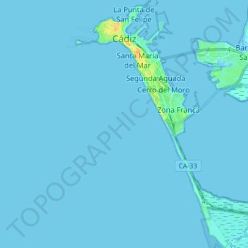
Name: Cádiz topographic map, elevation, terrain.
Location: Cádiz, Bay of Cádiz, Cádiz, Andalusia, Spain (36.44379 -6.31746 36.54546 -6.22506)
Average elevation: 1 m
Minimum elevation: -8 m
Maximum elevation: 32 m
Make a donation
Gear up for your next adventure:
As an Amazon Associate, this site earns from qualifying purchases at no extra cost to you.
Other topographic maps
Click on a map to view its topography, its elevation and its terrain.
Poblado de Doña Blanca
Spain > Andalusia > Bay of Cádiz > El Puerto de Santa María
Average elevation: 13 m
Pinar de los Guisos
Spain > Andalusia > Bay of Cádiz > Chiclana de la Frontera
Average elevation: 18 m