Geolocate

Denny topographic map

Click on the map to display elevation.

About this map

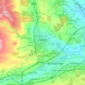
Name: Denny topographic map, elevation, terrain.

Location: Denny, Falkirk, Scotland, FK6 6EL, United Kingdom (55.98374 -3.94820 56.06374 -3.86820)

Average elevation: 86 m

Minimum elevation: 10 m

Maximum elevation: 253 m

Gear up for your next adventure:

🎒Backpack Rain Cover - External shield to keep your entire pack dry
🧢Hiking Hat - Sun-protective and breathable hats for long treks
🥾Hiking Leggings - Comfortable leggings for outdoor activities
Camping Essentials - All-in-one gear for a comfortable camping trip
🔭Outdoor Binoculars - Lightweight binoculars for birdwatching and hiking

As an Amazon Associate, this site earns from qualifying purchases at no extra cost to you.