
Make a donation
Gear up for your next adventure:
As an Amazon Associate, this site earns from qualifying purchases at no extra cost to you.
Nemrut Dağı topographic map
Click on the map to display elevation.
Make a donation
Gear up for your next adventure:
As an Amazon Associate, this site earns from qualifying purchases at no extra cost to you.
Nemrut Dağı
Lake Nemrut (Turkish: Nemrut gölü) is located in the south-western part of the caldera and is now a freshwater lake. Similar to Lake Van, under the influence of volcanic processes it is gradually becoming a saline lake. The lake is fed by hot springs, which is why it is warmer at the bottom than at the surface and does not freeze in winter. The total area is 4.9×2.1 km, the average depth is 140 m, and the maximum depth is 176 m; the altitude of the lake is 2,247 m (7,372 ft) above the sea level.
Make a donation
Gear up for your next adventure:
As an Amazon Associate, this site earns from qualifying purchases at no extra cost to you.
About this map
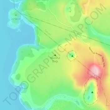
Name: Nemrut Dağı topographic map, elevation, terrain.
Location: Nemrut Dağı, Güroymak, Bitlis, Eastern Anatolia Region, Turkey (38.62245 42.24667 38.62255 42.24677)
Average elevation: 2,329 m
Minimum elevation: 2,242 m
Maximum elevation: 2,485 m
Make a donation
Gear up for your next adventure:
As an Amazon Associate, this site earns from qualifying purchases at no extra cost to you.
Other topographic maps
Click on a map to view its topography, its elevation and its terrain.
Lake Nemrut
Lake Nemrut is situated at an elevation of about 2,247 m (7,372 ft) above main sea level. It has an area of 12.36 km2 (4.77 sq mi), and its average depth is about 100 m (330 ft) with a maximum depth of 176 m (577 ft).
Average elevation: 2,347 m