Geolocate

Restrepo topographic map

Click on the map to display elevation.

About this map

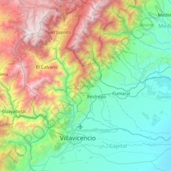
Name: Restrepo topographic map, elevation, terrain.

Location: Restrepo, Piedemonte, Meta, Colombia (4.12763 -73.63490 4.46152 -73.11270)

Average elevation: 1,304 m

Minimum elevation: 248 m

Maximum elevation: 3,971 m

Other topographic maps

Click on a map to view its topography, its elevation and its terrain.

Serrania La Lindosa

Colombia > Meta > Puerto Concordia

Average elevation: 269 m

San Gabriel

Colombia > Meta > San Martín

Average elevation: 224 m

Puerto Gaitán

Colombia > Meta > Puerto Carreño > Puerto Gaitán

Average elevation: 161 m

Villavicencio

Colombia > Meta > Villavicencio > Villavicencio

Average elevation: 672 m

Gear up for your next adventure:

🩹Compact First Aid Kit - Pre-packed essentials for common trail injuries
🦶Hiking Shoe Insoles - Added support for high arches and long days on feet
👖Convertible Hiking Pants - Zip-off legs to adapt to changing weather conditions
🥾Trail Hiking Shoes - Durable shoes designed for rugged trails
Family Camping Tent - Spacious tent suitable for family camping trips

As an Amazon Associate, this site earns from qualifying purchases at no extra cost to you.