
Calbayog topographic map
Click on the map to display elevation.
Calbayog
Forty percent of the city's land area are plain and hilly terrains with elevation ranging from 5 to 20 metres (16 to 66 ft) above sea level. The rest are rugged mountain ranges with elevations from 300 to 700 metres (980 to 2,300 ft) above sea level. Flooding is minimized because of many rivers, brooks, streams and natural water conveyors that flow towards the sea.
About this map
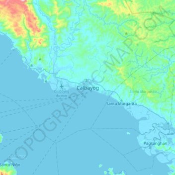
Name: Calbayog topographic map, elevation, terrain.
Location: Calbayog, Samar, Eastern Visayas, 6710, Philippines (11.90696 124.43467 12.22696 124.75467)
Average elevation: 55 m
Minimum elevation: -2 m
Maximum elevation: 662 m
Other topographic maps
Click on a map to view its topography, its elevation and its terrain.