
Murcia topographic map
Click on the map to display elevation.
Murcia
Murcia is located near the center of a low-lying fertile plain known as the huerta (orchard or vineyard) of Murcia. The Segura River and its right-hand tributary, the Guadalentín, run through the area. The city has an elevation of 43 metres (141 ft) above sea level and its municipality covers approximately 882 square kilometres (341 sq mi).
About this map
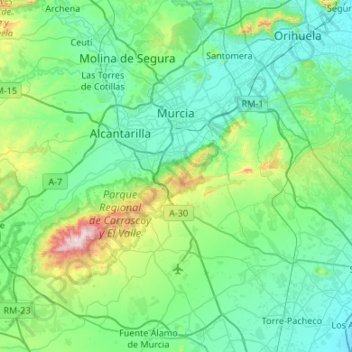
Name: Murcia topographic map, elevation, terrain.
Location: Murcia, Área Metropolitana de Murcia, Region of Murcia, Spain (37.71587 -1.38555 38.11789 -0.85089)
Average elevation: 171 m
Minimum elevation: 2 m
Maximum elevation: 1,055 m