Geolocate

Midlothian topographic map

Click on the map to display elevation.

About this map

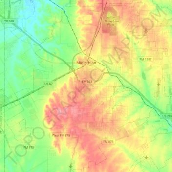
Name: Midlothian topographic map, elevation, terrain.

Location: Midlothian, Ellis County, Texas, 76065, United States (32.37739 -97.08636 32.54210 -96.90214)

Average elevation: 212 m

Minimum elevation: 159 m

Maximum elevation: 277 m

Other topographic maps

Click on a map to view its topography, its elevation and its terrain.

Alsdorf

United States > Texas > Ellis County

Average elevation: 119 m

Bristol

United States > Texas > Ellis County

Average elevation: 139 m

Gear up for your next adventure:

🧶550 Survival Paracord - Versatile utility cord for emergency repairs and rigging
💡LED Camping Lantern - Illuminate your campsite with long-lasting lanterns
🔥Camping Stove - Portable stoves to cook outdoors with ease
🌡️Emergency Mylar Blankets - Compact thermal protection for unexpected nights outdoors
🧢Hiking Hat - Sun-protective and breathable hats for long treks

As an Amazon Associate, this site earns from qualifying purchases at no extra cost to you.