
Make a donation
Gear up for your next adventure:
As an Amazon Associate, this site earns from qualifying purchases at no extra cost to you.
Guadalupe topographic map
Click on the map to display elevation.
Make a donation
Gear up for your next adventure:
As an Amazon Associate, this site earns from qualifying purchases at no extra cost to you.
Guadalupe
The Guadalupe River has its origins near the town in the Sierra de las Villuercas. Its highest point, the Pico la Villuerca reaches an altitude of 1603 m.
Make a donation
Gear up for your next adventure:
As an Amazon Associate, this site earns from qualifying purchases at no extra cost to you.
About this map
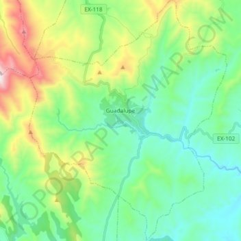
Name: Guadalupe topographic map, elevation, terrain.
Location: Guadalupe, Cáceres, Extremadura, 10140, Spain (39.39094 -5.38285 39.50366 -5.26272)
Average elevation: 763 m
Minimum elevation: 460 m
Maximum elevation: 1,560 m
Make a donation
Gear up for your next adventure:
As an Amazon Associate, this site earns from qualifying purchases at no extra cost to you.
Other topographic maps
Click on a map to view its topography, its elevation and its terrain.
Madrigal de la Vera
Spain > Extremadura > La Vera > Madrigal de la Vera > Madrigal de la Vera
Average elevation: 400 m
Make a donation
Gear up for your next adventure:
As an Amazon Associate, this site earns from qualifying purchases at no extra cost to you.