
Thank you for supporting this site ❤️
Make a donation
Make a donation
Gear up for your next adventure:
As an Amazon Associate, this site earns from qualifying purchases at no extra cost to you.
Mursallı topographic map
Click on the map to display elevation.
Thank you for supporting this site ❤️
Make a donation
Make a donation
Gear up for your next adventure:
As an Amazon Associate, this site earns from qualifying purchases at no extra cost to you.
About this map
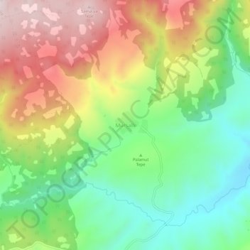
Name: Mursallı topographic map, elevation, terrain.
Location: Mursallı, Şarköy, Tekirdağ, Marmara Region, Turkey (40.70574 27.21520 40.74574 27.25520)
Average elevation: 346 m
Minimum elevation: 106 m
Maximum elevation: 666 m
Thank you for supporting this site ❤️
Make a donation
Make a donation
Gear up for your next adventure:
As an Amazon Associate, this site earns from qualifying purchases at no extra cost to you.