Geolocate

Banha topographic map

Click on the map to display elevation.

About this map

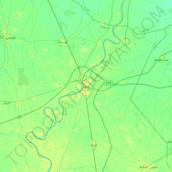
Name: Banha topographic map, elevation, terrain.

Location: Banha, Al Qalyubiya, 13512, Egypt (30.30250 31.02406 30.62250 31.34406)

Average elevation: 13 m

Minimum elevation: 6 m

Maximum elevation: 24 m

Other topographic maps

Click on a map to view its topography, its elevation and its terrain.

Bahada

Egypt > Al Qalyubiya

Average elevation: 16 m

El Obour

Egypt > Al Qalyubiya

Average elevation: 78 m

Al Salam First

Egypt > Al Qalyubiya

Average elevation: 31 m

Akyad Digawy

Egypt > Al Qalyubiya

Average elevation: 15 m

El Moushir Ahmed Ismail

Egypt > Al Qalyubiya

Average elevation: 71 m

Gear up for your next adventure:

🔦LED Headlamp - Hands-free lighting for early morning starts or late finishes
🧢Outdoor Visor - Breathable visor for sunny hikes
🧭Orienteering Kit - Tools for map reading and navigation in the wild
🧥Waterproof Jacket - Lightweight rain jackets for hiking and outdoor activities
📷Outdoor Action Camera - Capture high-elevation views and rugged adventures

As an Amazon Associate, this site earns from qualifying purchases at no extra cost to you.