Geolocate

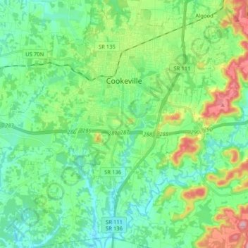
Cookeville topographic map

Click on the map to display elevation.

Cookeville

Located on the Highland Rim, Cookeville's elevation (1100 ft AMSL) is a few hundred feet higher than Nashville's or Knoxville's. As a result, temperatures and humidity levels are generally slightly lower in Cookeville than in either the Nashville Basin or the Tennessee Valley.

Wikipedia (CC-BY-SA 3.0)

About this map

Name: Cookeville topographic map, elevation, terrain.

Location: Cookeville, Putnam County, Middle Tennessee, Tennessee, United States (36.08048 -85.59951 36.19927 -85.44160)

Average elevation: 332 m

Minimum elevation: 276 m

Maximum elevation: 483 m

Other topographic maps

Click on a map to view its topography, its elevation and its terrain.
Buffalo Valley

United States > Tennessee > Putnam County

Average elevation: 203 m

Silver Point

United States > Tennessee > Putnam County

Average elevation: 291 m

Springdale

United States > Tennessee > Putnam County > Cookeville

Average elevation: 331 m

Silver Point

United States > Tennessee > Putnam County

Average elevation: 291 m

Samaria

United States > Tennessee > Putnam County

Average elevation: 312 m

Eastwood

United States > Tennessee > Putnam County > Cookeville

Average elevation: 337 m

Hillwood

United States > Tennessee > Putnam County > Cookeville

Average elevation: 323 m

Gear up for your next adventure:

🌡️Emergency Mylar Blankets - Compact thermal protection for unexpected nights outdoors
🛶Canoe Life Vest - Safety vest for water sports
🧥Softshell Hiking Jacket - The perfect balance of wind protection and breathability
🥾Waterproof Hiking Shoes - Durable shoes for wet and rugged trails
⛺Camping Groundsheet - Protect your tent from moisture and dirt

As an Amazon Associate, this site earns from qualifying purchases at no extra cost to you.