Geolocate

Båstad topographic map

Click on the map to display elevation.

About this map

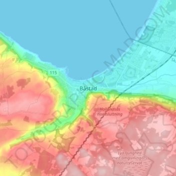
Name: Båstad topographic map, elevation, terrain.

Location: Båstad, Båstads kommun, Skåne County, 269 38, Sweden (56.38679 12.82072 56.46679 12.90072)

Average elevation: 79 m

Minimum elevation: 0 m

Maximum elevation: 203 m

Other topographic maps

Click on a map to view its topography, its elevation and its terrain.

Malmo

Sweden > Skåne County

Average elevation: 10 m

Osby kommun

Sweden > Skåne County

Average elevation: 116 m

Gear up for your next adventure:

💧Hydration Pack - Hands-free hydration system for long hikes
Backpacking Tent - Lightweight tent for long-distance hiking trips
🥾Hiking Leggings - Comfortable leggings for outdoor activities
🔭Compact Monocular - One-handed bird watching and trail spotting
🧢Hiking Hat - Sun-protective and breathable hats for long treks

As an Amazon Associate, this site earns from qualifying purchases at no extra cost to you.