Geolocate

Deggendorf topographic map

Click on the map to display elevation.

About this map

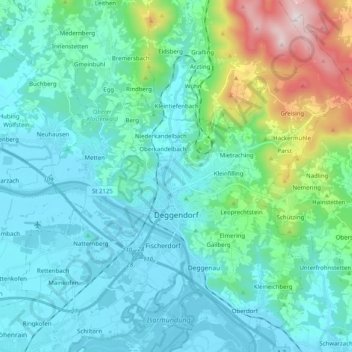
Name: Deggendorf topographic map, elevation, terrain.

Location: Deggendorf, Landkreis Deggendorf, Bavaria, 94469, Germany (48.78686 12.87356 48.90861 13.07415)

Average elevation: 449 m

Minimum elevation: 309 m

Maximum elevation: 1,101 m

Gear up for your next adventure:

🧥Waterproof Hiking Jacket - Protect yourself from rain and wind while hiking
Backpacking Tent - Lightweight tent for long-distance hiking trips
💧Filtered Water Bottle - Safe drinking water on the go
Bushcraft Tarp - Versatile emergency shelter or gear protection
💡Portable Camping Lamp - Rechargeable lamp for campsite lighting

As an Amazon Associate, this site earns from qualifying purchases at no extra cost to you.