Geolocate

Melazzo topographic map

Click on the map to display elevation.

About this map

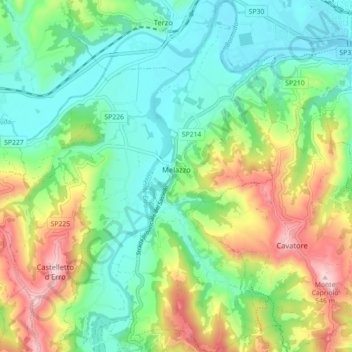
Name: Melazzo topographic map, elevation, terrain.

Location: Melazzo, Alessandria, Piemont, Italy (44.61108 8.38387 44.67441 8.45027)

Average elevation: 272 m

Minimum elevation: 143 m

Maximum elevation: 537 m

Gear up for your next adventure:

🗺️Topographic Maps - Detailed maps to explore trails, mountains, and wilderness areas
🛰️Satellite Messenger - Emergency communication for areas with no cell service
🧦Thermal Socks - Warm socks for winter hiking or camping
🥘Camping Cookware Set - Compact nesting pots and pans for trail cooking
🧢Hiking Sun Hat - Wide-brimmed protection for exposed mountain ridges

As an Amazon Associate, this site earns from qualifying purchases at no extra cost to you.