
Anápolis topographic map
Click on the map to display elevation.
Anápolis
Anápolis is located in Center-Western Brazil. It is located in a plateau, called Central Plateau, at an elevation of 1,017 metres (3,337 ft). The area is 918.3 square kilometres (354.6 sq mi), and the limiting municipalities are Abadiânia, Campo Limpo de Goiás, Gameleira de Goiás, Goianápolis, Leopoldo de Bulhões, Nerópolis, Pirenópolis, Silvânia and Terezópolis de Goiás. Anápolis is also the center of the Anápolis Microregion, and belongs to the Goiás Center mesoregion.
About this map
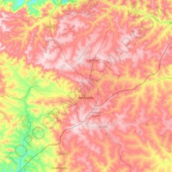
Name: Anápolis topographic map, elevation, terrain.
Average elevation: 984 m
Minimum elevation: 722 m
Maximum elevation: 1,153 m
Other topographic maps
Click on a map to view its topography, its elevation and its terrain.
Rosa
Brazil > Goiás > Região Integrada de Desenvolvimento do Distrito Federal e Entorno > Pirenópolis
Average elevation: 780 m
Bom Jesus
Brazil > Goiás > Região Integrada de Desenvolvimento do Distrito Federal e Entorno > Pirenópolis
Average elevation: 760 m
Rio Arraial Velho
Brazil > Goiás > Região Integrada de Desenvolvimento do Distrito Federal e Entorno > Água Fria de Goiás
Average elevation: 847 m
Paiol Velho
Brazil > Goiás > Região Integrada de Desenvolvimento do Distrito Federal e Entorno > Pirenópolis
Average elevation: 730 m