Geolocate

Gräfelfing topographic map

Click on the map to display elevation.

About this map
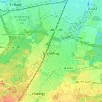
Name: Gräfelfing topographic map, elevation, terrain.

Location: Gräfelfing, Landkreis München, Bavaria, 82166, Germany (48.10676 11.39996 48.13756 11.46567)

Average elevation: 543 m

Minimum elevation: 526 m

Maximum elevation: 564 m

Other topographic maps

Click on a map to view its topography, its elevation and its terrain.
Eglfing

Germany > Bavaria > Landkreis München > Haar

Average elevation: 540 m

Martinsried

Germany > Bavaria > Landkreis München > Planegg

Average elevation: 549 m

Hofolding

Germany > Bavaria > Landkreis München

Average elevation: 609 m

Holzhausen

Germany > Bavaria > Landkreis München

Average elevation: 663 m

Deisenhofen

Germany > Bavaria > Landkreis München > Oberhaching

Average elevation: 592 m

Gear up for your next adventure:

🌡️Emergency Mylar Blankets - Compact thermal protection for unexpected nights outdoors
⛺Family Camping Tent - Spacious tent suitable for family camping trips
🧥Waterproof Jacket - Lightweight rain jackets for hiking and outdoor activities
⛺Backpacking Tent - Lightweight tent for long-distance hiking trips
🧭GPS Tracker - Track your location in remote areas safely

As an Amazon Associate, this site earns from qualifying purchases at no extra cost to you.