Geolocate

Taupō topographic map

Click on the map to display elevation.

About this map

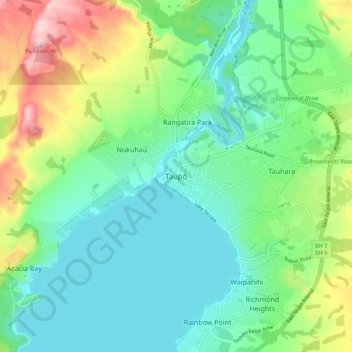
Name: Taupō topographic map, elevation, terrain.

Location: Taupō, Taupō District, Waikato, 3377, New Zealand (-38.72662 176.02948 -38.64662 176.10948)

Average elevation: 423 m

Minimum elevation: 349 m

Maximum elevation: 609 m

Other topographic maps

Click on a map to view its topography, its elevation and its terrain.

Hauhungaroa Range

New Zealand > Waikato > Taupo District

Average elevation: 753 m

Tongariro River

New Zealand > Waikato > Taupo District

Average elevation: 853 m

Lake Rotoaira

New Zealand > Waikato > Taupo District

Average elevation: 624 m

Lake Rotokawa

New Zealand > Waikato > Taupo District

Average elevation: 358 m

Lake Rotopounamu

New Zealand > Waikato > Taupo District

Average elevation: 784 m

Summit Plateau

New Zealand > Waikato > Taupo District

Average elevation: 2,454 m

Motutaiko Island

New Zealand > Waikato > Taupo District

Average elevation: 357 m

Gear up for your next adventure:

Camping Tent - Weather-resistant tents suitable for 2 to 6 people
🔨Vehicle Emergency Tool - Safety tool for remote road trips to trailheads
🚑Survival Whistle - Signal for help across long distances in mountains
🥾Trail Hiking Boots - Supportive boots for rough trails
🎒Hiking Backpack - Lightweight and ergonomic backpacks for day hikes or multi-day treks

As an Amazon Associate, this site earns from qualifying purchases at no extra cost to you.