
Sanya City topographic map
Interactive map
Click on the map to display elevation.
About this map
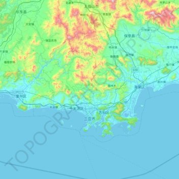
Name: Sanya City topographic map, elevation, terrain.
Location: Sanya City, Hainan Province, China (18.14384 108.92817 18.63020 109.80695)
Average elevation: 168 m
Minimum elevation: -4 m
Maximum elevation: 1,435 m
Sanya lies at the southern tip of Hainan Island on Sanya Bay. Located at 18° 15' N latitude, Sanya is–after Sansha (also administered by Hainan Province)–the second-southernmost prefecture-level city nationally. Though the administrative area (Sanya City) has a rough topography, the city itself is generally flat, lying on a parcel of land between low-level mountains to the north and the South China Sea.
Other topographic maps
Click on a map to view its topography, its elevation and its terrain.
CN/VN disputes in Paracel Islands
CN/VN disputes in Paracel Islands, Hainan Province, 573199, China
Average elevation: 0 m