
Blanc-Sablon topographic map
Interactive map
Click on the map to display elevation.
About this map
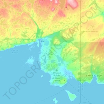
Name: Blanc-Sablon topographic map, elevation, terrain.
Average elevation: 94 m
Minimum elevation: -2 m
Maximum elevation: 392 m
Other topographic maps
Click on a map to view its topography, its elevation and its terrain.
Lac du Feu
Canada > Quebec > Le Golfe-du-Saint-Laurent > Petit-Mécatina
Lac du Feu, Petit-Mécatina, Le Golfe-du-Saint-Laurent, Côte-Nord, Quebec, Canada
Average elevation: 88 m
Lac Chenil
Canada > Quebec > Le Golfe-du-Saint-Laurent > Petit-Mécatina
Lac Chenil, Petit-Mécatina, Le Golfe-du-Saint-Laurent, Côte-Nord, Quebec, Canada
Average elevation: 354 m
Unamen Shipu
Canada > Quebec > Le Golfe-du-Saint-Laurent > Unamen Shipu
Unamen Shipu, Le Golfe-du-Saint-Laurent, Côte-Nord, Quebec, Canada
Average elevation: 6 m