Geolocate

Abisko topographic map

Click on the map to display elevation.

Abisko

Permafrost is common around the village albeit this low altitude permafrost is disappearing because of global warming and increased snowfall.

Wikipedia (CC-BY-SA 3.0)

About this map

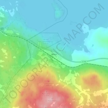
Name: Abisko topographic map, elevation, terrain.

Location: Abisko, Kiruna kommun, Norrbotten County, 981 07, Sweden (68.33017 18.81001 68.37017 18.85001)

Average elevation: 395 m

Minimum elevation: 340 m

Maximum elevation: 533 m

Other topographic maps

Click on a map to view its topography, its elevation and its terrain.

Pajala kommun

Sweden > Norrbotten County

Average elevation: 262 m

Gear up for your next adventure:

🧰Emergency Multi-Tool - Compact multi-tool for outdoor survival
🕶️Polarized Sunglasses - Protect your eyes with durable polarized lenses
🥾Trail Hiking Socks - Comfortable socks to prevent blisters and fatigue
Camping Coffee Maker - Brew fresh coffee anywhere on the topographic map
🥾Hiking Boots - Sturdy boots providing ankle support and traction on rugged trails

As an Amazon Associate, this site earns from qualifying purchases at no extra cost to you.