Geolocate

Province of Huaral topographic map

Click on the map to display elevation.

About this map

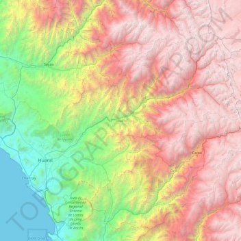
Name: Province of Huaral topographic map, elevation, terrain.

Location: Province of Huaral, Lima, Peru (-11.67832 -77.38269 -11.01348 -76.45693)

Average elevation: 2,414 m

Minimum elevation: 0 m

Maximum elevation: 5,302 m

Other topographic maps

Click on a map to view its topography, its elevation and its terrain.

Valdiviezo

Peru > Lima > Santa María

Average elevation: 77 m

Province of Huarochirí

Peru > Lima

Average elevation: 2,632 m

Rio Cañete

Peru > Lima > Huancachi

Average elevation: 4,031 m

Santa Bárbara

Peru > Lima > San Luis

Average elevation: 5 m

Gear up for your next adventure:

Lightweight Camping Tent - Portable shelter optimized for Canadian backcountry camping
🧭GPS Handheld Device - Reliable GPS navigation for outdoor adventures
🧴First Aid Kit - Essential first aid supplies for outdoor emergencies
🕶️Polarized Sunglasses - Reduces glare from snow and water at high elevations
🧭GPS Tracker - Track your location in remote areas safely

As an Amazon Associate, this site earns from qualifying purchases at no extra cost to you.