
Make a donation
Gear up for your next adventure:
As an Amazon Associate, this site earns from qualifying purchases at no extra cost to you.
Régina topographic map
Click on the map to display elevation.
Make a donation
Gear up for your next adventure:
As an Amazon Associate, this site earns from qualifying purchases at no extra cost to you.
About this map
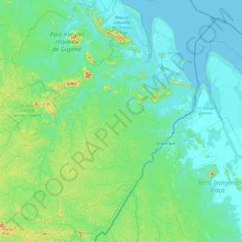
Name: Régina topographic map, elevation, terrain.
Location: Régina, Saint-Georges, French Guiana, 97390, France (3.18874 -53.23319 4.78907 -51.75012)
Average elevation: 63 m
Minimum elevation: -3 m
Maximum elevation: 654 m
Make a donation
Gear up for your next adventure:
As an Amazon Associate, this site earns from qualifying purchases at no extra cost to you.
Other topographic maps
Click on a map to view its topography, its elevation and its terrain.
Make a donation
Gear up for your next adventure:
As an Amazon Associate, this site earns from qualifying purchases at no extra cost to you.
Make a donation
Gear up for your next adventure:
As an Amazon Associate, this site earns from qualifying purchases at no extra cost to you.
Saint-Laurent-du-Maroni
France > French Guiana > Saint-Laurent-du-Maroni > Saint-Laurent-du-Maroni
Average elevation: 9 m