
Make a donation
Gear up for your next adventure:
As an Amazon Associate, this site earns from qualifying purchases at no extra cost to you.
Tomkins Cove topographic map
Click on the map to display elevation.
Make a donation
Gear up for your next adventure:
As an Amazon Associate, this site earns from qualifying purchases at no extra cost to you.
About this map
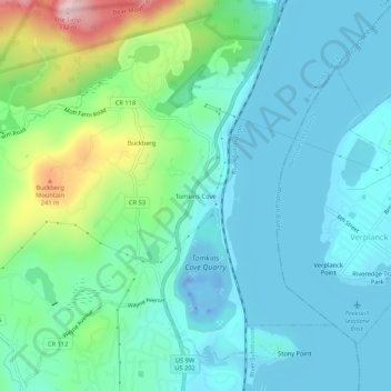
Name: Tomkins Cove topographic map, elevation, terrain.
Average elevation: 68 m
Minimum elevation: -43 m
Maximum elevation: 322 m
Make a donation
Gear up for your next adventure:
As an Amazon Associate, this site earns from qualifying purchases at no extra cost to you.
Other topographic maps
Click on a map to view its topography, its elevation and its terrain.
Bear Mountain State Park
United States > New York > Rockland County > Town of Stony Point
There are over 50 official trails covering 235 miles (378 km), featuring a wide range of difficulties and elevation changes.
Average elevation: 166 m
Salisbury Meadow
United States > New York > Rockland County > Town of Stony Point
Average elevation: 97 m