
Thank you for supporting this site ❤️
Make a donation
Make a donation
Gear up for your next adventure:
As an Amazon Associate, this site earns from qualifying purchases at no extra cost to you.
Clairton topographic map
Click on the map to display elevation.
Thank you for supporting this site ❤️
Make a donation
Make a donation
Gear up for your next adventure:
As an Amazon Associate, this site earns from qualifying purchases at no extra cost to you.
About this map
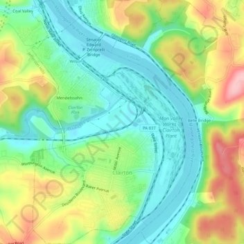
Name: Clairton topographic map, elevation, terrain.
Location: Clairton, Allegheny County, Pennsylvania, United States (40.28087 -79.90076 40.31982 -79.86684)
Average elevation: 281 m
Minimum elevation: 220 m
Maximum elevation: 384 m
Thank you for supporting this site ❤️
Make a donation
Make a donation
Gear up for your next adventure:
As an Amazon Associate, this site earns from qualifying purchases at no extra cost to you.
Other topographic maps
Click on a map to view its topography, its elevation and its terrain.
Bullock-Pens Park
United States > Pennsylvania > Allegheny County > Pittsburgh
Average elevation: 338 m