Geolocate

Londonderry topographic map

Click on the map to display elevation.

About this map

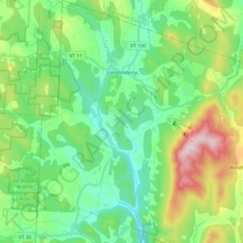
Name: Londonderry topographic map, elevation, terrain.

Location: Londonderry, Windham County, Vermont, United States (43.14171 -72.86480 43.26286 -72.72781)

Average elevation: 455 m

Minimum elevation: 277 m

Maximum elevation: 898 m

Gear up for your next adventure:

🌡️Emergency Mylar Blankets - Compact thermal protection for unexpected nights outdoors
👟Trail Running Shoes - Agile footwear for fast-paced topographic exploration
🧭GPS Tracker - Track your location in remote areas safely
🧭GPS Handheld Device - Reliable GPS navigation for outdoor adventures
🔨Vehicle Emergency Tool - Safety tool for remote road trips to trailheads

As an Amazon Associate, this site earns from qualifying purchases at no extra cost to you.