Geolocate

Cilengkrang topographic map

Click on the map to display elevation.

About this map

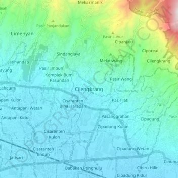
Name: Cilengkrang topographic map, elevation, terrain.

Location: Cilengkrang, Kabupaten Bandung, Java, 40169, Indonesia (-6.94492 107.65413 -6.86492 107.73413)

Average elevation: 804 m

Minimum elevation: 664 m

Maximum elevation: 1,536 m

Other topographic maps

Click on a map to view its topography, its elevation and its terrain.

Soreang

Indonesia > Kabupaten Bandung

Average elevation: 745 m

Gear up for your next adventure:

🧴Insect Repellent - Protect yourself from bugs during outdoor adventures
🦶Anti-Blister Balm - Prevents friction and hotspots during long ascents
🧳Compression Sacks - Maximize space in your backpack by shrinking gear
💧Hydration Pack - Hands-free hydration system for long hikes
🧰Survival Kit - Essential gear for emergencies in the wilderness

As an Amazon Associate, this site earns from qualifying purchases at no extra cost to you.