Geolocate

Silver Spring topographic map

Click on the map to display elevation.

About this map

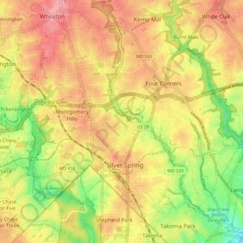
Name: Silver Spring topographic map, elevation, terrain.

Location: Silver Spring, Montgomery County, Maryland, United States (38.97966 -77.06371 39.01977 -76.97165)

Average elevation: 86 m

Minimum elevation: 12 m

Maximum elevation: 137 m

Gear up for your next adventure:

Family Camping Tent - Spacious tent suitable for family camping trips
🧭Orienteering Kit - Tools for map reading and navigation in the wild
🧤Rechargeable Heated Gloves - Extreme warmth for Canadian winter expeditions
🛶Canoe Life Vest - Safety vest for water sports
🥾Waterproof Hiking Boots - Boots keeping your feet dry in wet conditions

As an Amazon Associate, this site earns from qualifying purchases at no extra cost to you.