
Make a donation
Gear up for your next adventure:
As an Amazon Associate, this site earns from qualifying purchases at no extra cost to you.
Rhêmes-Notre-Dame topographic map
Click on the map to display elevation.
Make a donation
Gear up for your next adventure:
As an Amazon Associate, this site earns from qualifying purchases at no extra cost to you.
Rhêmes-Notre-Dame
Because of its altitude, winters are cold and snowy, while summers are fresh. Temperatures vary from a minimum value of −15 °C (5 °F) during winters to a maximum value of 22 to 23 °C (72 to 73 °F) during summers.
Make a donation
Gear up for your next adventure:
As an Amazon Associate, this site earns from qualifying purchases at no extra cost to you.
About this map
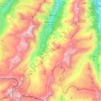
Name: Rhêmes-Notre-Dame topographic map, elevation, terrain.
Location: Rhêmes-Notre-Dame, Aosta Valley, Italy (45.46695 7.04254 45.59917 7.17040)
Average elevation: 2,628 m
Minimum elevation: 1,511 m
Maximum elevation: 3,580 m
Make a donation
Gear up for your next adventure:
As an Amazon Associate, this site earns from qualifying purchases at no extra cost to you.
Other topographic maps
Click on a map to view its topography, its elevation and its terrain.