
Make a donation
Gear up for your next adventure:
As an Amazon Associate, this site earns from qualifying purchases at no extra cost to you.
Damavand topographic map
Click on the map to display elevation.
Make a donation
Gear up for your next adventure:
As an Amazon Associate, this site earns from qualifying purchases at no extra cost to you.
Damavand
Mount Damavand (Persian: دماوند [dæmɒːvænd] ) is a dormant stratovolcano and is the highest peak in Iran and Western Asia, the highest volcano in Asia, and the 3rd highest volcano in the Eastern Hemisphere (after Mount Kilimanjaro and Mount Elbrus), at an elevation of 5,609 metres (18,402 ft). Damāvand has a special place in Persian mythology and folklore. It is in the middle of the Alborz range, adjacent to Varārū, Sesang, Gol-e Zard, and Mīānrūd. It is near the southern coast of the Caspian Sea, in Amol County, Mazandaran Province, 66 km (41 mi) northeast of the city of Tehran.
Make a donation
Gear up for your next adventure:
As an Amazon Associate, this site earns from qualifying purchases at no extra cost to you.
About this map
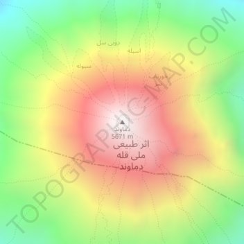
Name: Damavand topographic map, elevation, terrain.
Average elevation: 4,949 m
Minimum elevation: 4,345 m
Maximum elevation: 5,595 m
Make a donation
Gear up for your next adventure:
As an Amazon Associate, this site earns from qualifying purchases at no extra cost to you.