
Make a donation
Gear up for your next adventure:
As an Amazon Associate, this site earns from qualifying purchases at no extra cost to you.
Modriča topographic map
Click on the map to display elevation.
Make a donation
Gear up for your next adventure:
As an Amazon Associate, this site earns from qualifying purchases at no extra cost to you.
About this map
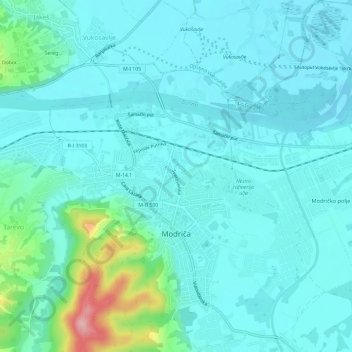
Name: Modriča topographic map, elevation, terrain.
Average elevation: 118 m
Minimum elevation: 93 m
Maximum elevation: 251 m
Make a donation
Gear up for your next adventure:
As an Amazon Associate, this site earns from qualifying purchases at no extra cost to you.
Other topographic maps
Click on a map to view its topography, its elevation and its terrain.
Lukavica
Bosnie-et-Herzégovine > République serbe de Bosnie > Град Источно Сарајево / Grad Istočno Sarajevo
Average elevation: 586 m
Make a donation
Gear up for your next adventure:
As an Amazon Associate, this site earns from qualifying purchases at no extra cost to you.
Pale
Bosnie-et-Herzégovine > République serbe de Bosnie > Град Источно Сарајево / Grad Istočno Sarajevo
Average elevation: 993 m
Make a donation
Gear up for your next adventure:
As an Amazon Associate, this site earns from qualifying purchases at no extra cost to you.