Geolocate

Waterloo topographic map

Click on the map to display elevation.

Waterloo

The average elevation of Waterloo is 846 feet above sea level. The population density is 1101 people per square mile, considered low for an urban area.

Wikipedia (CC-BY-SA 3.0)

About this map

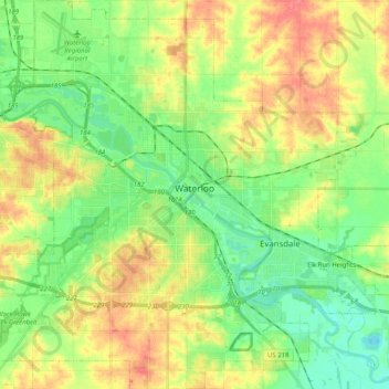
Name: Waterloo topographic map, elevation, terrain.

Location: Waterloo, Black Hawk County, Iowa, United States (42.42116 -92.43682 42.57049 -92.24886)

Average elevation: 272 m

Minimum elevation: 246 m

Maximum elevation: 307 m

Other topographic maps

Click on a map to view its topography, its elevation and its terrain.

Washburn

United States > Iowa > Black Hawk County

Average elevation: 258 m

Dewar

United States > Iowa > Black Hawk County

Average elevation: 279 m

Jubilee

United States > Iowa > Black Hawk County

Average elevation: 269 m

Gear up for your next adventure:

💧Hydration Bladder - Hands-free hydration solution for long treks
🥾Approach Shoes - Shoes designed for climbing approaches and rugged trails
🔨Vehicle Emergency Tool - Safety tool for remote road trips to trailheads
🕶️Polarized Sunglasses - Protect your eyes with durable polarized lenses
🧥Insulated Jacket - Keep warm in cold outdoor conditions

As an Amazon Associate, this site earns from qualifying purchases at no extra cost to you.