Geolocate

Cheekha Dar topographic map

Click on the map to display elevation.

Cheekha Dar

It was climbed in November 2004 by English explorer Ginge Fullen, who recorded a GPS reading of 3,628 meters at the coordinates in the adjacent table. The location is consistent with SRTM and Russian topographic mapping, although these sources are more consistent with the CIA height.

Wikipedia (CC-BY-SA 3.0)

About this map

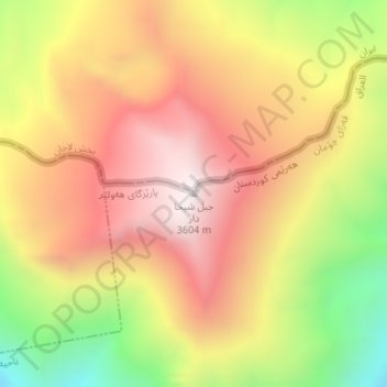
Name: Cheekha Dar topographic map, elevation, terrain.

Location: Cheekha Dar, Haji Omeran Subdistrict, Choman District, Erbil Governorate, Iraqi Kurdistan Region, Iraq (36.77547 44.91884 36.77557 44.91894)

Average elevation: 3,165 m

Minimum elevation: 2,587 m

Maximum elevation: 3,602 m

Other topographic maps

Click on a map to view its topography, its elevation and its terrain.

Gear up for your next adventure:

🥾Waterproof Hiking Boots - Boots keeping your feet dry in wet conditions
🥫Freeze-Dried Meals - Lightweight, high-calorie nutrition for multi-day treks
🧴Sunscreen SPF - Broad-spectrum sunscreen for outdoor activities
Family Camping Tent - Spacious tent suitable for family camping trips
🚲Heavy Duty Bike Lock - Secure your bike at the trailhead or during stops

As an Amazon Associate, this site earns from qualifying purchases at no extra cost to you.