Geolocate

Castro-Urdiales topographic map

Click on the map to display elevation.

About this map

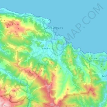
Name: Castro-Urdiales topographic map, elevation, terrain.

Location: Castro-Urdiales, Costa Oriental, Cantabria, Spain (43.28360 -3.33526 43.41913 -3.14965)

Average elevation: 189 m

Minimum elevation: -1 m

Maximum elevation: 820 m

Gear up for your next adventure:

🧢Outdoor Visor - Breathable visor for sunny hikes
🎒Hiking Backpack - Lightweight and ergonomic backpacks for day hikes or multi-day treks
🧥Ultralight Puffy Jacket - Maximum warmth that packs down to the size of an orange
🧦Hiking Socks - Moisture-wicking and comfortable socks for long hikes
Camping Tent - Weather-resistant tents suitable for 2 to 6 people

As an Amazon Associate, this site earns from qualifying purchases at no extra cost to you.