
Make a donation
Gear up for your next adventure:
As an Amazon Associate, this site earns from qualifying purchases at no extra cost to you.
Mülheim an der Ruhr topographic map
Click on the map to display elevation.
Make a donation
Gear up for your next adventure:
As an Amazon Associate, this site earns from qualifying purchases at no extra cost to you.
About this map
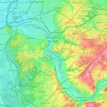
Name: Mülheim an der Ruhr topographic map, elevation, terrain.
Location: Mülheim an der Ruhr, North Rhine-Westphalia, Germany (51.35074 6.80667 51.47145 6.95954)
Average elevation: 70 m
Minimum elevation: 24 m
Maximum elevation: 169 m
Make a donation
Gear up for your next adventure:
As an Amazon Associate, this site earns from qualifying purchases at no extra cost to you.
Other topographic maps
Click on a map to view its topography, its elevation and its terrain.
Ödinghausen
Germany > North Rhine-Westphalia > Oberbergischer Kreis > Nümbrecht
Average elevation: 280 m
Vogelsang Internationaler Platz (IP)
Germany > North Rhine-Westphalia > Kreis Euskirchen > Schleiden
Average elevation: 429 m
Trupbach
Germany > North Rhine-Westphalia > Kreis Siegen-Wittgenstein > Siegen
Average elevation: 330 m
Make a donation
Gear up for your next adventure:
As an Amazon Associate, this site earns from qualifying purchases at no extra cost to you.
Make a donation
Gear up for your next adventure:
As an Amazon Associate, this site earns from qualifying purchases at no extra cost to you.
Straußberg
Germany > North Rhine-Westphalia > Kreis Minden-Lübbecke > Lübbecke
Average elevation: 176 m