Geolocate

Pine Mountain topographic map

Click on the map to display elevation.

About this map
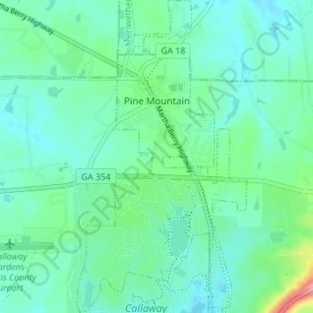
Name: Pine Mountain topographic map, elevation, terrain.

Location: Pine Mountain, Harris County, Georgia, United States (32.83003 -84.86985 32.88138 -84.83654)

Average elevation: 271 m

Minimum elevation: 244 m

Maximum elevation: 376 m

Other topographic maps

Click on a map to view its topography, its elevation and its terrain.
Whitesville

United States > Georgia > Harris County

Average elevation: 207 m

Dowdell Knob

United States > Georgia > Harris County

Average elevation: 322 m

Gear up for your next adventure:

🚲MTB Frame Bag - Carry tools and maps directly on your bicycle frame
🥽Outdoor Goggles - Protective eyewear for outdoor activities
⛺Backpacking Tent - Lightweight tent for long-distance hiking trips
💡LED Headlamp - Hands-free illumination for night hiking and camping
🧥Thermal Layer - Insulating layer for cold outdoor conditions

As an Amazon Associate, this site earns from qualifying purchases at no extra cost to you.