
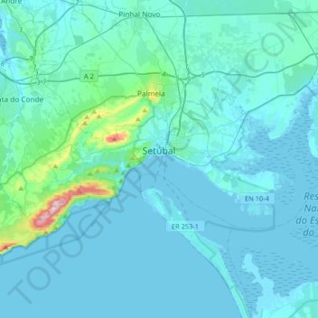
Setúbal topographic map
Interactive map
Click on the map to display elevation.
Setúbal topographic map, elevation, terrain
About this map
Name: Setúbal topographic map, elevation, terrain.
Location: Setúbal, Portugal (38.45396 -9.05562 38.58072 -8.73139)
Average elevation: 35 m
Minimum elevation: -4 m
Maximum elevation: 485 m
Other topographic maps
Click on a map to view its topography, its elevation and its terrain.
Nature Park of Arrábida
This group is oriented east-northeast to west-southwest, covering an area of about 35 kilometres (22 mi) long and 6 kilometres (3.7 mi) wide, and reaching 501 metres (1,644 ft) at its highest altitude as a result of the Formosinho anticline. Arrábida was formed from four successive phases of rifting that…
Average elevation: 45 m
Colonato de Santo Isidro de Pegões
Portugal > Setúbal > Santo Isidro de Pegões
Average elevation: 67 m