Geolocate

Real Sitio topographic map

Click on the map to display elevation.

About this map

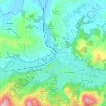
Name: Real Sitio topographic map, elevation, terrain.

Location: Real Sitio, La Cavada, Trasmiera, Cantabria, 39720, Spain (43.33172 -3.72867 43.37172 -3.68867)

Average elevation: 121 m

Minimum elevation: 33 m

Maximum elevation: 400 m

Gear up for your next adventure:

🧴Sunscreen SPF - Broad-spectrum sunscreen for outdoor activities
🧴Insect Repellent - Protect yourself from bugs during outdoor adventures
🥫Freeze-Dried Meals - Lightweight, high-calorie nutrition for multi-day treks
👟Trail Running Shoes - Agile footwear for fast-paced topographic exploration
🥾Mountaineering Boots - Supportive boots for climbing and high-altitude hiking

As an Amazon Associate, this site earns from qualifying purchases at no extra cost to you.