Geolocate

Maimi topographic map

Click on the map to display elevation.

About this map

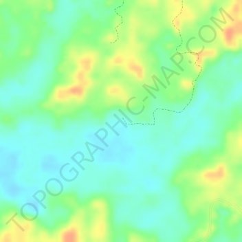
Name: Maimi topographic map, elevation, terrain.

Location: Maimi, Sabana de Torres, Yariguíes, Santander, Colombia (7.21010 -73.49544 7.23010 -73.47544)

Average elevation: 147 m

Minimum elevation: 129 m

Maximum elevation: 173 m

Gear up for your next adventure:

🛶Kayak Dry Bag - Waterproof storage for kayaking adventures
🥾Approach Boots - Comfortable boots for hiking and climbing approaches
🛁Quick-Dry Microfiber Towel - Space-saving towel that dries rapidly on the move
🥾Light Hiking Boots - Lightweight and comfortable boots for day hikes
🛶Waterproof Dry Bags - Keep electronics and clothes dry during river crossings

As an Amazon Associate, this site earns from qualifying purchases at no extra cost to you.